

Unmanned Aircraft Systems (UAS)
Cowlitz County UAS Team was formed to assist with aerial Search & Rescue activities. During emergencies & disasters, the team can respond to floods, landslides, earthquakes, storms and HAZMAT incidents to provide valuable information to Emergency Management and Incident Commanders without putting anyone in harms way.
The team can also assist with accident and fire investigation documentation. The UAS team works hand-in-hand with Cowlitz County Emergency Management, who is very instrumental in the team’s activities.
Emergency Management spent many hours building the team’s policy, informational hanouts and screening calls for the team’s response. The Cowlitz County UAS team will support other agencies on missions, but does not respond to law enforcement activities.
Emergency Locator Transmitter(ELT) - Radio Direction Finding
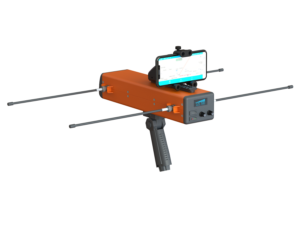
Radio direction finding is the use of receiving equipment and directional antennae to locate a signal source. Cowlitz County ACS has been involved with finding Emergency Locator Transmitters for a number of years.
These devices are used on general aviation aircraft and boats (called EPIRB in marine use) as automatically activated distress beacons. Specialized equipment is used to triangulate a position on the ground when the activated signal is detected. Periodic drills are held with a test transmitter so teams can practice their skills.
When a signal is detected, field units radio their location and signal heading to a central mapping team. This is similar to a traditional amateur radio “Foxhunt”, except it is a team effort and not a competition. The goal is to locate the beacon as quickly and safely as possible, which requires coordination and cooperation among all team members.